Bosai Solution Map : Search Results
Hazard
Solution Purpose
Solution Theme
Now Loading
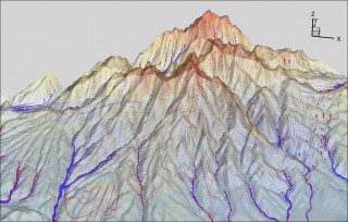
3 Dimensional Integrated Water Cycle Simulation Model (GETFLOWS)
Yachiyo Engineering Co., Ltd.
- Flood
- Prevention & Mitigation
- Research & Investigation
- Risk Assessment
- Disaster Prevention Plan
- Infrastructure Technology
- Building Technology
- Information & Communication Technology
- Education & Training
- Technical Research & Development
- Feasibility Study
- Hazard Identification
- Hazard Simulation
- Risk Monitoring
- Impact & Damage Simulation
- Legislation & Technical Regulations
- Mitigation Plan
- River & Basin
- Dam & Reservoir
- Coast
- Urban
- Facility for Disaster Prevention
- Information Analysis & Judgement
- Human Resource Development
- Educational Publication
- Training & Exercises
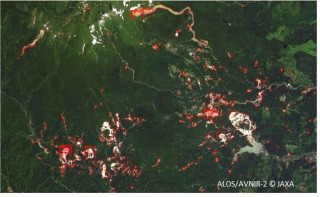
Automatic landslide area detection Service by using Satellite Image
Remote Sensing Technology Center of Japan
- Earthquake
- Land Slide
- Cyclone
- Prevention & Mitigation
- Recovery
- Research & Investigation
- Risk Assessment
- Disaster Prevention Plan
- Infrastructure Technology
- Information & Communication Technology
- Rescue & Medical Treatment
- Technical Research & Development
- Feasibility Study
- Risk Monitoring
- Impact & Damage Simulation
- Mitigation Plan
- Business Continuity Plan
- Road
- Information Analysis & Judgement
- Information Platform
- Emergency Rescue Operation
.png)
Building resilience in cities, regions, and businesses
Mitsubishi Research Institute, Inc.
- Earthquake
- Tsunami
- Cyclone
- Storm Surge
- Flood
- Prevention & Mitigation
- Response
- Recovery
- Research & Investigation
- Risk Assessment
- Disaster Prevention Plan
- Infrastructure Technology
- Information & Communication Technology
- Education & Training
- Evaluation
- Research
- Site Investigation
- Feasibility Study
- Hazard Simulation
- Impact & Damage Simulation
- Mitigation Plan
- Plan for Relief & Recovery Support
- Business Continuity Plan
- Urban
- Information Gathering
- Information Analysis & Judgement
- Human Resource Development
- Training & Exercises
- Post Training Evaluation
.jpg)
Flood Information Service by using Satellite Image
Remote Sensing Technology Center of Japan
- Tsunami
- Cyclone
- Flood
- Prevention & Mitigation
- Recovery
- Research & Investigation
- Risk Assessment
- Disaster Prevention Plan
- Finance & Insurance
- Infrastructure Technology
- Building Technology
- Information & Communication Technology
- Technical Research & Development
- Feasibility Study
- Impact & Damage Simulation
- Mitigation Plan
- Business Continuity Plan
- Proactive Investment
- River & Basin
- Port
- Urban
- Design & Construction of Resilient Building
- Information Gathering
- Information Analysis & Judgement
- Information Platform
.jpg)
Land Subsidence and Deformation Monitoring Service for Social Infrastructure
Remote Sensing Technology Center of Japan
- Earthquake
- Land Slide
- Prevention & Mitigation
- Recovery
- Research & Investigation
- Risk Assessment
- Disaster Prevention Plan
- Infrastructure Technology
- Building Technology
- Information & Communication Technology
- Technical Research & Development
- Feasibility Study
- Risk Monitoring
- Impact & Damage Simulation
- Mitigation Plan
- Business Continuity Plan
- Road
- Railways
- Airport
- Essential Utilities
- Urban
- Design & Construction of Resilient Building
- Information Gathering
- Information Analysis & Judgement
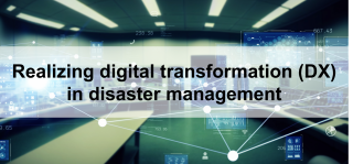
Realizing digital transformation (DX) in disaster management
Mitsubishi Research Institute, Inc.
- Earthquake
- Tsunami
- Cyclone
- Storm Surge
- Flood
- Prevention & Mitigation
- Preparedness
- Response
- Recovery
- Research & Investigation
- Risk Assessment
- Disaster Prevention Plan
- Infrastructure Technology
- Education & Training
- Evaluation
- Research
- Feasibility Study
- Hazard Simulation
- Impact & Damage Simulation
- Legislation & Technical Regulations
- Mitigation Plan
- Urban
- Human Resource Development
- Training & Exercises
- Post Training Evaluation
.png)
Stimulating the industry of disaster and climate resilience technologies
Mitsubishi Research Institute, Inc.
- Earthquake
- Tsunami
- Land Slide
- Cyclone
- Storm Surge
- Flood
- Prevention & Mitigation
- Preparedness
- Response
- Recovery
- Research & Investigation
- Disaster Prevention Plan
- Research
- Site Investigation
- Feasibility Study
- Legislation & Technical Regulations
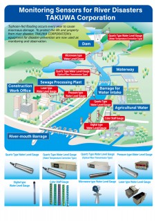
Water Monitoring Sensors for Preventing
Takuwa Corporation
- Tsunami
- Cyclone
- Storm Surge
- Flood
- Prevention & Mitigation
- Preparedness
- Response
- Research & Investigation
- Risk Assessment
- Infrastructure Technology
- Information & Communication Technology
- Products & Goods
- Feasibility Study
- Risk Monitoring
- River & Basin
- Dam & Reservoir
- Sabo
- Port
- Essential Utilities
- Urban
- Information Gathering
- Information Analysis & Judgement
- Information Communication
- Information Platform
- Machinery & Equipment