Bosai Solution ID : JBP00071
Land Subsidence and Deformation Monitoring Service for Social Infrastructure
Detecting Dangerous Spots in Social Infrastructure in their early stages. Contributing to Ensure a Safe, Secure and Robust Society
.jpg)
Hazard
Solution Purpose
Solution Theme
Research & Investigation
Risk Assessment
Disaster Prevention Plan
Infrastructure Technology
Building Technology
Information & Communication Technology
Technology Subject
Advantages
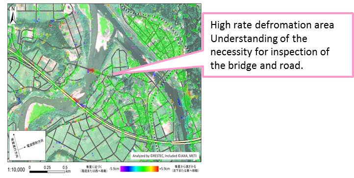
Satellites RADAR data is used in order to monitor extensive infrastructure networks. By analyzing RADAR data from past to present, land deformation to be detected on a scale of several centimeters annually. If a certain area is found to have experiences of significant land deformation, it can be assumed that local buildings and infrastructure are at risk. Furthermore, it leads to screening for investigation in detail and decision-making.
Solution Illustrated
Background
Social infrastructure such as railroads, roads, levees, dams as well as water, gas and power facilities extend their networks across the entire country, covering long distances. This means they are difficult to replace with new systems once they have been laid down. They are deteriorating as they age year by year and are in danger of falling apart as the result of earthquakes and land subsidence. Through monitoring facilities and locations, early detecting risk areas and maintenance of them, the original strength of the social infrastructure can be sustainable. However, lots of time and cost are required due to monitor and inspection manually by professionals in wide area. It is the issue to establish efficient monitoring system.
Exposition of the Solution
Inspections are currently carried out in vehicles, manually by professionals, or based on reports from local residents. This requires a lot of time and money. Early detection of damage or risk areas requires streamlining the monitoring system. Using satellites allows extensive infrastructure networks to be covered all at once. Furthermore, using a Synthetic Aperture Radar (SAR) allows land deformation to be detected on a scale of several millimeters to several centimeters annually. For example, if a certain area is found to have experiences land deformation, it can be assumed that local buildings and infrastructure are at risk. Based on such assumptions, decisions can be quickly made to dispatch engineers to inspect the site. Moreover, the use of a high resolution satellite will allow deformation in the buildings themselves to be detected. For example, in the case of bridges, deformation due to heat can be monitored on a scale of millimeters to detect damage before any breakdown occurs. RESTEC is the only organization in Japan possessing this technology.
Land deformation is a problem that also affects artificial ground. It can also affect landfill sites for rubble left over from earthquakes, which there will no doubt be more of in the future. This problem is also expected to occur in developing countries where social infrastructure is currently under construction. Our aim is to engage in active research and development, and examine ways of creating a new service that can be put into practical use in Japan first, to contribute to establishing a safe, secure and robust social infrastructure. After accomplishing this, we hope to expand our service overseas.
Land deformation is a problem that also affects artificial ground. It can also affect landfill sites for rubble left over from earthquakes, which there will no doubt be more of in the future. This problem is also expected to occur in developing countries where social infrastructure is currently under construction. Our aim is to engage in active research and development, and examine ways of creating a new service that can be put into practical use in Japan first, to contribute to establishing a safe, secure and robust social infrastructure. After accomplishing this, we hope to expand our service overseas.
Achievements of Examples
There were many examples of analysis for ground deformation of domestic and abroad area in project and joint research. For the purpose of the facility inspection and land risk judgment material, we are preparing for providing information as standard service for enterprise.
Corporate Profile
Remote Sensing Technology Center of Japan
TOKYU REIT Toranomon Building 2F 3-17-1 Toranomon, Minato – ku, Tokyo 105 – 0001, Japan
Tel. : +81-3-6435-6700
E-mail : R-JBPrestec.or.jp
Website : https://www.restec.or.jp/en/