
Bosai Solution ID : JBP00090
Landslide terrain interpretation technology by use of AI
An example of technology for interpreting dead trees and terrains using deep learning, and examination of its applicability to civil engineering and sabo fields
Hazard
Solution Purpose
Solution Theme
Technology Subject
Advantages
Compared to the method of terrain interpretation by a civil engineer, the interpretation result can be obtained in a few minutes. Therefore, it can be highly applicable in labor-saving of interpretation and quick grasp of the situation immediately after the occurrence of sediment disasters.
Solution Illustrated
Background
Surveys and diagnoses in the fields of civil engineering and sabo are usually conducted based on the empirical knowledge and tacit knowledge of civil engineers. A typical example of it is the technology for interpreting landslide terrain. This is a technology that interprets the characteristic terrain at the site of sediment disasters and predicts the risk of it. However, such kind of work tends to cause individual differences due to the experience of engineers, and the amount of work is also a heavy burden. Therefore, expectations are increasing to the fields of civil engineering and sabo for the application of interpretation technology using deep learning, which is unified and can obtain the results in a short time.
Exposition of the Solution
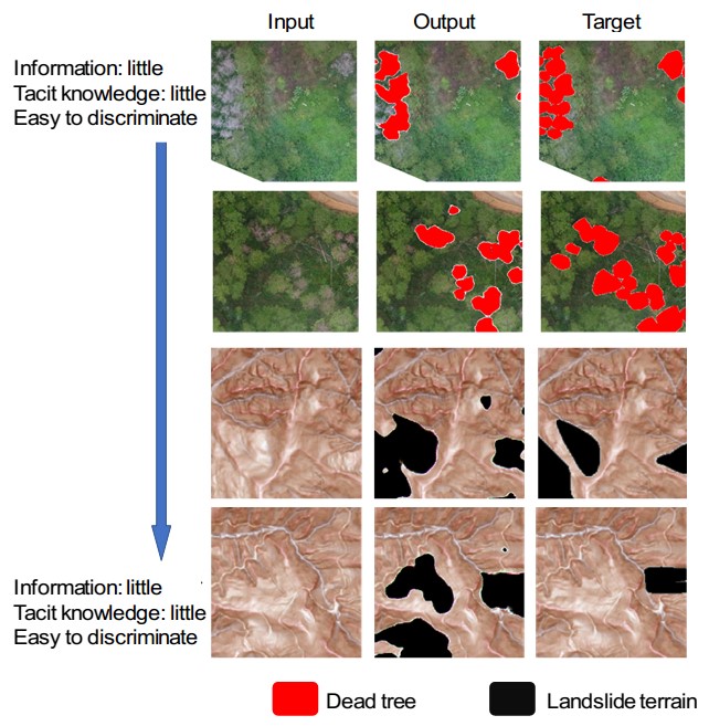
The interpretation of dead trees and landslide terrain contains the tacit knowledge of civil engineers. How much this can be learned by deep learning has been confirmed in this study. Pix2pix is used as a deep learning algorithm.
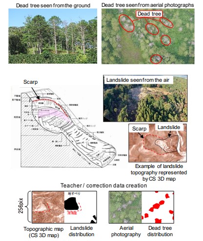
The teacher data used for interpreting dead trees was aerial photographs taken with a drone, and the teacher data for landslide terrain interpretation was landslide terrain data and CS three-dimensional map. The landslide topography data was created using the landslide topography distribution map published by the National Research Institute for Earth Science and Disaster Resilience (NIED), and the CS three-dimensional map was created based on the elevation data published by the Geospatial Information Authority of Japan. The number of teacher data for interpreting dead trees and landslide terrain interpretation was approximately 4,300 and 4,600, respectively. (Results are shown in Solution Illustrated )
The teacher data used for interpreting dead trees was aerial photographs taken with a drone, and the teacher data for landslide terrain interpretation was landslide terrain data and CS three-dimensional map. The landslide topography data was created using the landslide topography distribution map published by the National Research Institute for Earth Science and Disaster Resilience (NIED), and the CS three-dimensional map was created based on the elevation data published by the Geospatial Information Authority of Japan. The number of teacher data for interpreting dead trees and landslide terrain interpretation was approximately 4,300 and 4,600, respectively. (Results are shown in Solution Illustrated )
Achievements of Examples
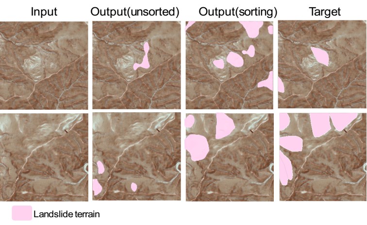
Example of landslide terrain image generation result (unsorted/sorting teacher data)
Corporate Profile
Nippon Koei Co., Ltd.
5-4 Kojimachi, Chiyoda-ku, Tokyo 102-8539, JAPAN
Tel. : +81-3-5276-3596
E-mail : int.agx.n-koei.co.jp
Website : http://www.n-koei.co.jp/english