
Bosai Solution ID : JBP00106
Prediction technology for slope behavior during earthquakes using numerical analysis
Determination of the effectiveness of countermeasure construction considering earthquakes
Hazard
Solution Purpose
Solution Theme
Technology Subject
Advantages
In order to reduce slope disasters during an earthquake, it is necessary to extract dangerous slopes in advance and take both soft and hard measures. This technology first extracts relatively dangerous areas in a wide area by Analytic Hierarchical Process(AHP) analysis. Next, it is a technology to predict the slope behavior at the time of an earthquake at a place judged to be dangerous by three-dimensional numerical analysis. Furthermore, it is possible to evaluate the effect of hard measures on individual slopes against earthquakes.
Solution Illustrated
Background
In addition to direct human damage caused by landslides slope disasters during an earthquake cause enormous damage such as the formation of natural dams due to landslides, flooding due to the subsequent collapse of natural dams, and long-term road closures. Both software and hardware measures are required to reduce damage, but it is necessary to take measures efficiently with a limited budget.
Exposition of the Solution
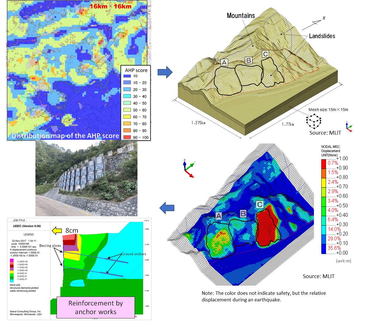
AHP is a method to support decision-making by providing evaluation indices which are computed by simulating the experts’ evaluation processes. AHP software has been developed to obtain the areal hazard distribution of earthquake-induced landslides. We have calibrated and applied the software to extract hazardous slopes by layering and quantifying the judgment process of experts based on topography, geology, and seismic motion factors related to earthquake-induced landslides.
For example, when explaining topographical factors, landslides tend to occur during an earthquake in places where the vertical profile of the slope is convex and the relative height of the mountains is large (Fig.2). Therefore, factors such as topography, geology, and earthquake motion are ranked, and the points for each factor are added to calculate the risk evaluation score. Then, the hazard map shown in the distribution map based on the evaluation points is created.
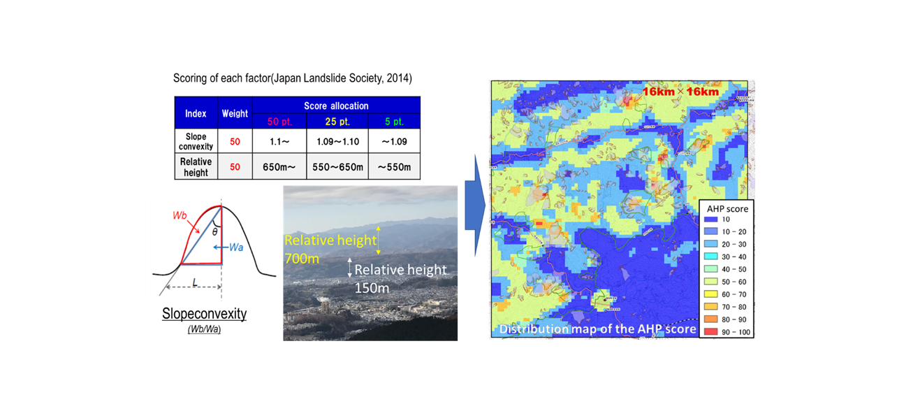

Fig.2 AHP scoring of topographical factors
In the past, hazard mapping required the advanced know-how and time of experienced specialists, but this technology has made it possible to extract dangerous slopes objectively and in a short time.
Next, we will evaluate the slope behavior during an earthquake in detail using numerical analysis for the areas evaluated by AHP as having a relatively high risk of slope disasters. Using the geological classification based on the geological and soil survey and the physical characteristics of the ground including landslides, we calculated which slope would become unstable in the event of an assumed seismic motion for an area of approximately 2 km2 (Fig.3) .
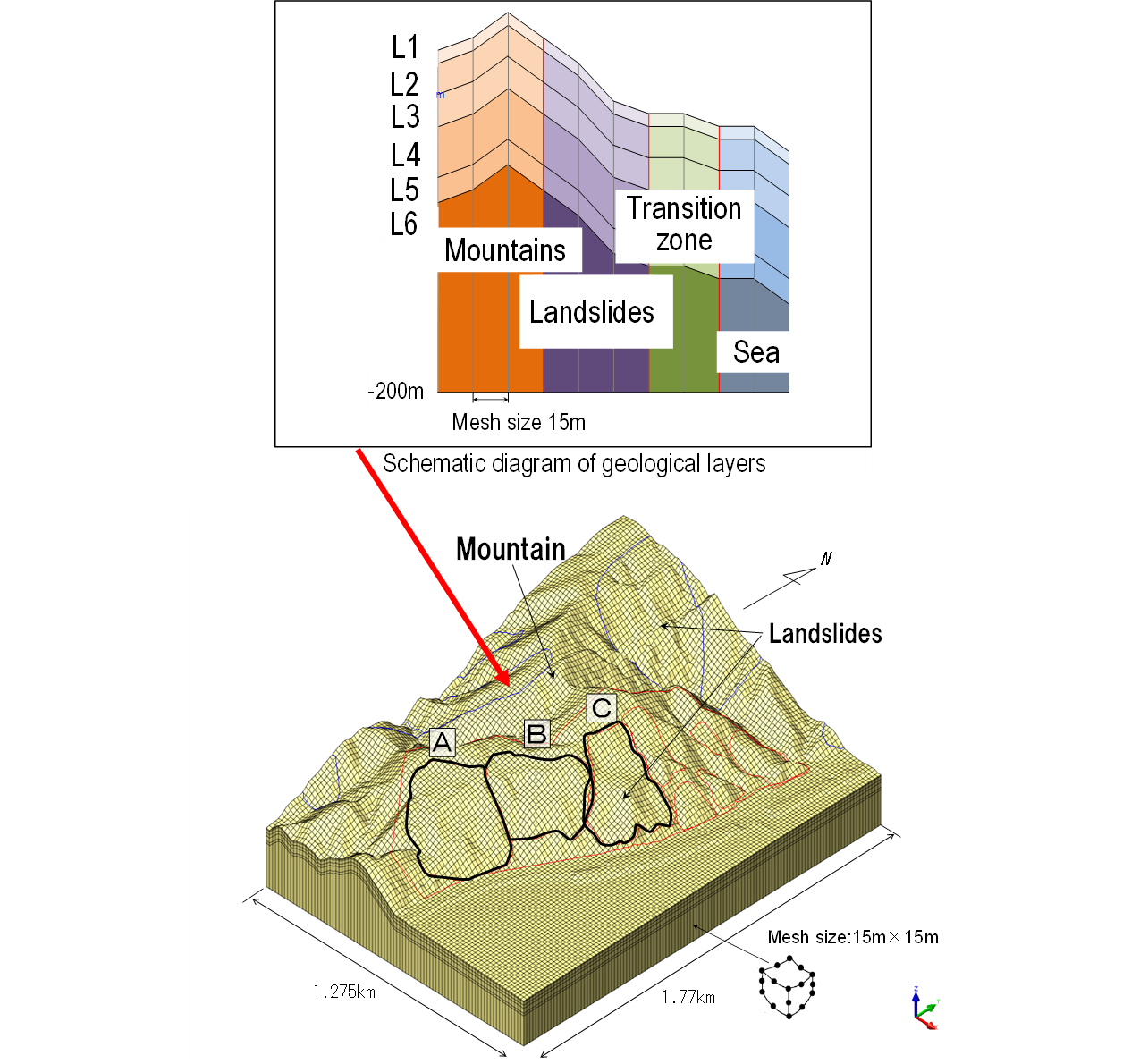
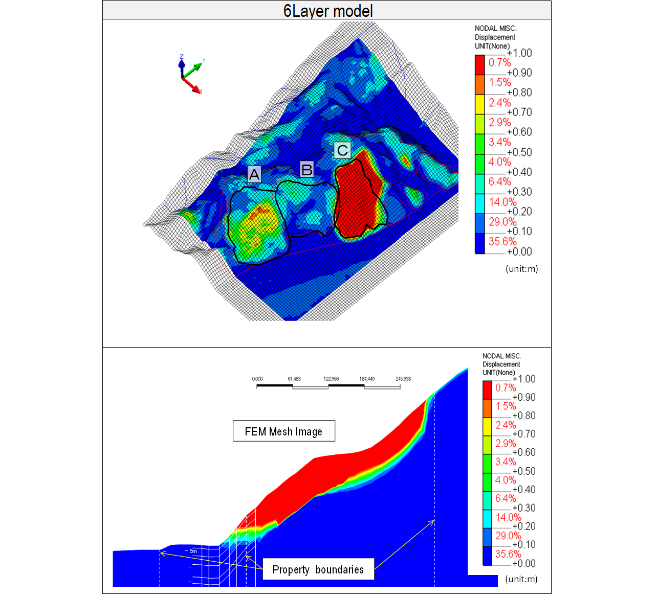
Fig.3 Bird's-eye view and cross-sectional view of residual displacement distribution by numerical analysis Source:MLIT
As shown in the figure, the displacement of the ground differs depending on the flat location and depth, so a range with a large swing width and a relatively high risk is extracted.
We conducted a two-dimensional seismic response analysis on the anchor work constructed as a reinforcement measure for the Gabion retaining wall damaged by the 2015 Gorkha earthquake in Nepal and verified the effect of the anchor on the earthquake (Fig.4).

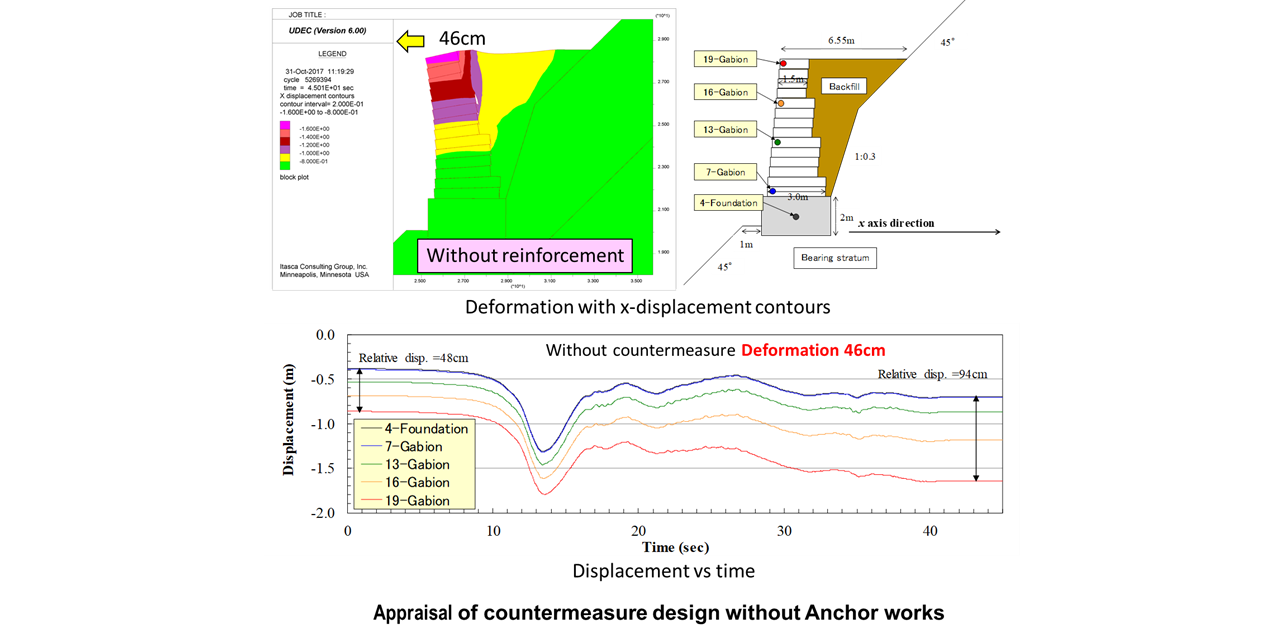
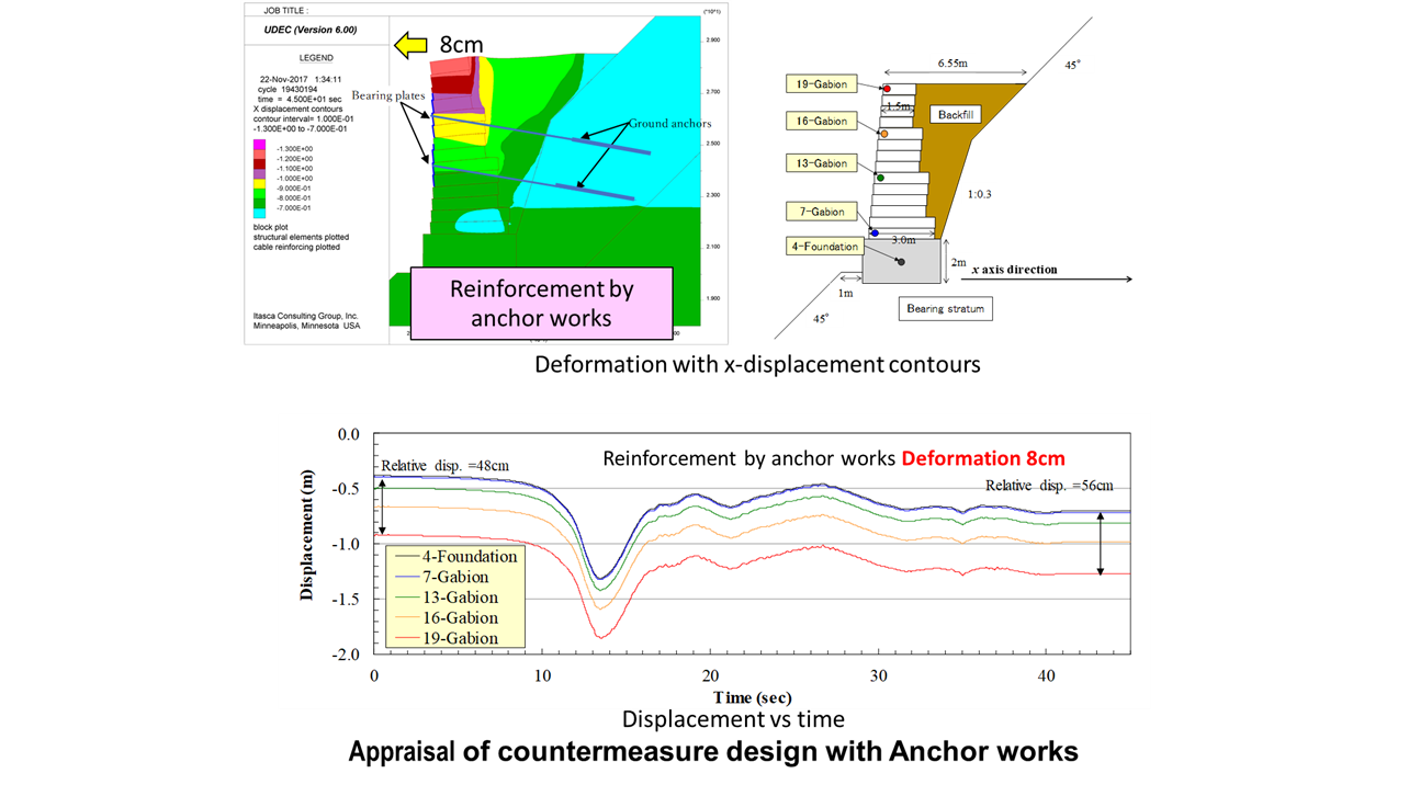
Fig.4 Reinforcement effect of anchor works predicted by two-dimensional seismic response analysis
For example, when explaining topographical factors, landslides tend to occur during an earthquake in places where the vertical profile of the slope is convex and the relative height of the mountains is large (Fig.2). Therefore, factors such as topography, geology, and earthquake motion are ranked, and the points for each factor are added to calculate the risk evaluation score. Then, the hazard map shown in the distribution map based on the evaluation points is created.
Fig.2 AHP scoring of topographical factors
In the past, hazard mapping required the advanced know-how and time of experienced specialists, but this technology has made it possible to extract dangerous slopes objectively and in a short time.
Next, we will evaluate the slope behavior during an earthquake in detail using numerical analysis for the areas evaluated by AHP as having a relatively high risk of slope disasters. Using the geological classification based on the geological and soil survey and the physical characteristics of the ground including landslides, we calculated which slope would become unstable in the event of an assumed seismic motion for an area of approximately 2 km2 (Fig.3) .
Fig.3 Bird's-eye view and cross-sectional view of residual displacement distribution by numerical analysis Source:MLIT
As shown in the figure, the displacement of the ground differs depending on the flat location and depth, so a range with a large swing width and a relatively high risk is extracted.
We conducted a two-dimensional seismic response analysis on the anchor work constructed as a reinforcement measure for the Gabion retaining wall damaged by the 2015 Gorkha earthquake in Nepal and verified the effect of the anchor on the earthquake (Fig.4).
Fig.4 Reinforcement effect of anchor works predicted by two-dimensional seismic response analysis
Achievements of Examples
・Risk assessment of road slopes destabilized by earthquakes
・Judgment of the effect of countermeasures such as anchor works and steel pile works etc. against collapses and landslides during an earthquake
・Judgment of the effect of countermeasures such as anchor works and steel pile works etc. against collapses and landslides during an earthquake
Corporate Profile
Nippon Koei Co., Ltd.
5-4 Kojimachi, Chiyoda-ku, Tokyo 102-8539, JAPAN
Tel. : +81-3-5276-3596
E-mail : int.agx.n-koei.co.jp
Website : http://www.n-koei.co.jp/english